Inside the dams, farms, fisheries and early-warning systems testing whether Nile cooperation can turn Africa’s most contested river into a shared engine of development
By Ayele Addis Ambelu (ANC) May 12, 2026, Addis Ababa, Ethiopia. (Analysis)
The bridge changed the meaning of the river
For Adam Yusuf, the meaning of the Nile was once painfully local. He lives near Rusumo Falls in Rwanda’s Kirehe District, close to the border with Tanzania. For years, the promise of a major regional hydropower project sounded like something belonging to governments, engineers and international financiers.
Then the road and bridge arrived.
“In 2015, local leaders told us that at Rusumo Hydropower Falls Rusumo International Bridge and One-Stop Border Post project was going to be built on the border and that the benefits would come back to us,” Yusuf told Africa News Channel. “We did not understand this because we felt that the benefits are from the government and the citizens will get nothing.”
That perception began to change when infrastructure built alongside the project helped reconnect communities to markets. The bridge, Yusuf said, had previously been damaged by erosion, interrupting the movement of crops to the Kigarama market. After its reconstruction, farmers could move produce more easily, while a market at the Rusumo border began attracting Tanzanian shoppers.
“The market has expanded,” he said. For Yusuf, the most important part of the regional project was therefore not the turbine. It was the bridge.
That distinction matters.
For years, public discussion of the Nile has been dominated by dams, treaties, water allocations, diplomatic disputes and geopolitical anxiety. Yet for millions of people living along the Basin, water politics eventually becomes something much simpler: Can I irrigate my field? Can I get fish from the lake? Can my child reach school when the river rises? Can I turn on a light? Can I know that a flood is coming before it reaches my home?
Those questions reveal another Nile.
It is a Nile where cooperation is being tested not only in ministerial meetings but in markets, farms, fishing communities, electricity grids, groundwater wells and early-warning systems.
And that is where one of Africa’s most politically sensitive river basins is quietly experimenting with a different proposition: shared water does not have to produce only shared anxiety. It can produce shared benefits.
A river usually described as a dispute
The Nile is routinely presented through the language of conflict. Ethiopia’s Grand Ethiopian Renaissance Dam has transformed the politics of the Blue Nile. Egypt and Sudan have expressed concerns about downstream water security, while Ethiopia has argued that hydropower development is essential for its own development and can coexist with downstream interests.
In 2024, the Cooperative Framework Agreement for the Nile River Basin entered into force after the required ratifications were secured, despite Egypt and Sudan not joining the agreement. The political disagreement has not disappeared. But beneath that argument is a different regional reality.
The Nile Basin is also a laboratory for cooperation. The Nile Basin Initiative, established in 1999, brings together ten Nile Basin countries in a framework for cooperation on shared water resources. Its investment arm, the Nile Equatorial Lakes Subsidiary Action Program, has supported projects involving energy, irrigation, water supply, flood management, fisheries, ecosystems and climate resilience.
The February 2026 NBI country-benefits report describes a portfolio that includes completed, ongoing and pipeline investments designed to translate regional cooperation into tangible development outcomes.
Its figures are striking. An 80-megawatt hydropower project at Rusumo Falls connects Burundi, Rwanda and Tanzania. Basin-wide climate-resilience programmes operate across ten countries. Transboundary water projects are designed to support irrigation, drinking-water supply, flood control and watershed restoration.
Hon. James Mawich Makuach, Minister of Water Resources and Irrigation of South Sudan, described in the 2026 Nile Day media event “The Nile is not just water flowing through our land, it is opportunity flowing toward our future. Through cooperation, we are turning shared waters into shared prosperity.”
The NBI Report assured its wider portfolio contributes to irrigation covering tens of thousands of hectares, improved water services reaching hundreds of thousands of people, watershed management across hundreds of square kilometres and flood and drought early-warning systems serving ten countries.
But those figures also demand a harder journalistic question: What does cooperation actually feel like at community level? The answer is emerging in places far from diplomatic conference rooms.
Nile Connects: A dam that is supposed to be more than a dam
On the Kenya-Uganda border, the Angololo Water Resources Development Project offers perhaps the clearest example of what the new Nile story could look like.
The project is designed around the Malaba River, which forms part of the Kenya-Uganda border system. The original idea was simple: instead of each country attempting to manage the resource separately, they would jointly develop it. But the proposed infrastructure is anything but simple.
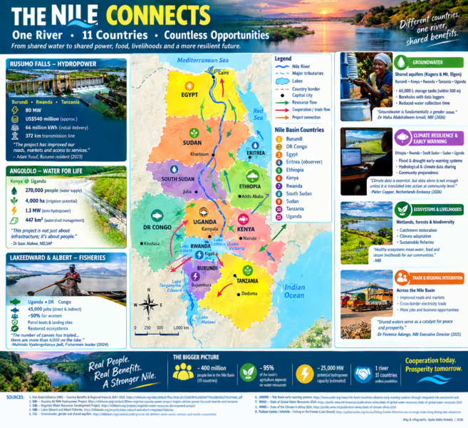
The project combines water storage, irrigation, drinking water, watershed management, flood-risk reduction, hydropower, livestock and fisheries. The NBI’s 2026 country-benefits publication gives the wider project design an irrigation potential of roughly 4,300 hectares, water supply for up to 270,000 people, around 430 square kilometres of watershed management and approximately 1.3 MW of mini-hydropower generation.
Independent reporting on the project adds another dimension: inclusion. At the 2025 signing of the bilateral agreement, Ugandan officials and project representatives repeatedly framed the investment around women, youth and local economic opportunity.
Uganda’s Minister for Water and Environment, Beatrice Anywar, said women would benefit from reduced water burdens and new opportunities in farming and trade.
NELSAP Regional Coordinator Dr Isaac Alukwe put the principle more bluntly: “This project is not just about infrastructure; it’s about people.”
NBI Executive Director Dr Florence Adongo described the agreement as a transition from years of negotiations toward implementation, saying: “Shared waters serve as a catalyst for peace and prosperity.”
Those statements are political commitments, not proof of completed impact. That distinction is crucial. Angololo is not yet a finished development success story. It remains a project moving through structuring, financing and implementation stages, with full operation expected later in the decade.
The real solution, therefore, is not yet the dam. The solution is the decision by two countries to design, finance and manage a shared resource together. That may sound less dramatic than a completed reservoir. It may ultimately be more important.
The Angololo test: can a promise become a public asset?
Angololo also exposes the central weakness of many infrastructure narratives. Governments can announce hectares. Engineers can announce megawatts. Development institutions can announce investment volumes. But farmers experience water differently.
They experience it as the difference between planting once and planting twice. Between losing a crop and harvesting it. Between carrying water for kilometres and finding it close to home. Between watching a river flood a field and having a functioning drainage system.
The project’s design attempts to connect those realities. Its feasibility and preparation work includes environmental and social assessments, resettlement planning and detailed engineering.
In 2026, Angololo received certification under the Blue Dot Network, an international infrastructure-quality framework. The certification is significant because it evaluates issues including sustainability, transparency, resilience, financial viability and social safeguards.
Yet certification is not the same as community impact. The strongest test will come later: Will the promised water actually reach households? Will smallholder farmers gain reliable access to irrigation? Will women experience measurable reductions in unpaid water-collection work? Will young people obtain jobs beyond temporary construction? Will fisheries and downstream ecosystems remain viable? And will the communities on both sides of the border have meaningful influence over how the resource is managed? Those are the questions that should follow the project into its next phase.
Dr. Isaac Alukwe water resources engineer, and governance leader said “the project demonstrates how cooperative water resources development can simultaneously deliver irrigation, clean water, renewable energy, ecosystem restoration, and regional integration while meeting internationally recognized standards for transparency, resilience, and investment readiness. Angololo is proudly showcasing Africa’s capacity to develop world-class infrastructure that is attracting global attention and inspiring future investments.”
Power of the People Rusumo: when electricity crosses a border
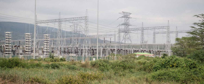
At Rusumo Falls, the story is further advanced. The 80 MW Regional Rusumo Falls Hydroelectric Project was developed jointly for Burundi, Rwanda and Tanzania. The NBI’s records an investment of approximately US$540 million.
But the electricity is only one layer of the story. A World Bank assessment has described the project as capable of generating about 448 gigawatt-hours of electricity annually, with transmission infrastructure connecting the beneficiary countries. Burundi, Rwanda and Tanzania each receive a share of the generation.
That creates something larger than a power station. It creates an example of infrastructure whose economic geography is regional from the beginning. A river does not stop at a customs post. Neither should the benefits of carefully managed water.
The World Bank has long used Rusumo as an example of the logic behind transboundary cooperation: one project can generate benefits across several countries while reducing the duplication that occurs when governments act independently.
But the communities living around the project provide the more intimate measure. Adam Yusuf speaks about roads and markets. Laurence Uwamariya, a farmer in Rusumo village, spoke about irrigation. “Our hope is based on the dams we will have after the activities of building Rusumo Hydropower,” she said “We will have enough water and will help us in irrigation.”
Patricia Uwingabire spoke about another dimension: restoration. “NELSAP told us that they will provide us seeds of trees in order to protect the environment and replant trees destroyed by construction activities,” she said. These voices complicate the standard infrastructure story.
The community is not simply asking for electricity. It is asking whether the project can leave behind a stronger local economy, better roads, functioning public services, restored vegetation and reliable water for farming. That is what makes a transboundary infrastructure project a development project rather than merely an engineering project.
The bridge, the school and the market
The Rusumo experience also illustrates something frequently missing from international water debates: secondary benefits. A power project may produce electricity. But the investment around it can change roads. Roads change access to schools. Schools change attendance. Bridges change markets. Markets change the value of agricultural production.
Electricity changes the possibilities for small businesses. This is why the NBI describes its investments not simply as water projects but as interventions in energy security, food production, climate resilience, ecosystems and regional economic integration.
In Rusumo, residents interviewed described improved roads and a border market that brought Tanzanian customers to Rwandan producers. Those are not abstract indicators. They are evidence of how infrastructure can create effects beyond its original engineering purpose.
But there is another side. Projects of this scale can also produce displacement, environmental disruption, changes in land use and unequal distribution of benefits. The World Bank project documents show that resettlement and social safeguards were required. A solutions story that ignores those costs becomes publicity. A credible solutions story does the opposite: it asks whether the gains outweigh the costs and whether safeguards actually work.
Water is the solution: when the solution is underground
The Nile story is not only about dams. Some of its most promising interventions are almost invisible. Groundwater is one of them. Regional groundwater project lead Dr Maha Abdelraheem Ismail. Her central argument was striking: “Groundwater is fundamentally a gender issue.” Why? Because the burden of finding water frequently falls on women.
Ismail said women across parts of Africa can spend a significant share of their day collecting water, time that could otherwise be spent on income-generating activities, education or skills development.
The NBI groundwater pilots are operating in Burundi, Kenya, Rwanda, Tanzania and Uganda, focusing on shared aquifers including the Kagera and Mount Elgon systems. The project has installed storage tanks of up to 60 cubic metres near targeted communities.
According to the NBI, the tanks are located within 500 metres of communities and can reduce collection time dramatically. The project also drilled 20 boreholes fitted with data loggers in the Kagera aquifer to improve regional groundwater monitoring. Here, cooperation is taking a different form. There is no giant dam to photograph. No turbine hall. No spectacular reservoir.
Instead there are wells, data loggers, storage tanks, women carrying shorter distances and scientists comparing information across national boundaries. It is less visible. It may be more immediately transformative for some households. And it raises another important lesson: Water cooperation must not become synonymous with mega-infrastructure.
NBI’s Head of the Basin wide Program and Deputy Executive Director, Dr Abraha Adugna, said “The Strategic Water Resources Analysis tells us what the future could look like if we continue with business as usual. These pilots show how cooperation and innovation can help change that future. We are not simply building pilot systems; we are generating the evidence countries need to make better decisions for the entire Nile Basin.”
The water beneath countries
The Kagera aquifer illustrates why the future of the Nile cannot be managed only by looking at rivers. Water moves underground. Groundwater systems can cross political boundaries even when the surface landscape looks divided. That means a borehole drilled in one country can be connected to a wider hydrogeological system shared with neighbours.
Managing that resource requires data. It requires common monitoring. It requires trust. And it requires countries to share information about a resource that is physically invisible.
The NBI says scientists working on the groundwater programme have developed a regional action plan based on knowledge and data sharing, institutional frameworks for transboundary governance and capacity building.
The project has also exposed weaknesses. Ismail acknowledged gaps in reliable, quality-assured data, difficulties in site selection, land ownership issues and regulatory weaknesses. That admission is important. The solution is not being presented as perfect. Instead, the pilot is functioning as a learning system. A project discovers a problem. The problem exposes a policy gap. The policy gap becomes a reason to improve national regulation. That is what a real solution can look like.
One Issue: the Nile’s warning system
A river can be dangerous not only because there is too little water. Too much water can be equally destructive. Across the Nile Basin, floods and droughts are becoming increasingly difficult to manage as climate variability intensifies. The World Meteorological Organization’s State of Global Water Resources 2024 reported that only about one-third of the world’s river basins experienced normal conditions in 2024. The rest were above or below average.
The message is simple: Water is becoming less predictable. For a basin shared by multiple countries, unpredictability makes cooperation more valuable. A flood does not wait for a government ministry to issue a diplomatic note. A drought does not recognize an international boundary. A warning system therefore has to travel faster than the hazard.
In April 2026, the United Nations Office for Disaster Risk Reduction reported that Ethiopia, Rwanda, South Sudan, Sudan and Uganda were strengthening cooperation on multi-hazard risk assessment and flood early warning. The objective was not merely to improve forecasts. It was to turn forecasts into action.
Pieter Copper, Deputy Head of Mission at the Embassy of the Netherlands in Rwanda, summarized the problem: “Climate data is essential, but data alone is not enough unless it is translated into policies, contingency planning, and action at community level.”
That sentence captures perhaps the biggest challenge facing the Nile’s emerging data revolution. A warning that never reaches a farmer is only information. A forecast that does not trigger preparedness is not yet resilience.
From data to a decision
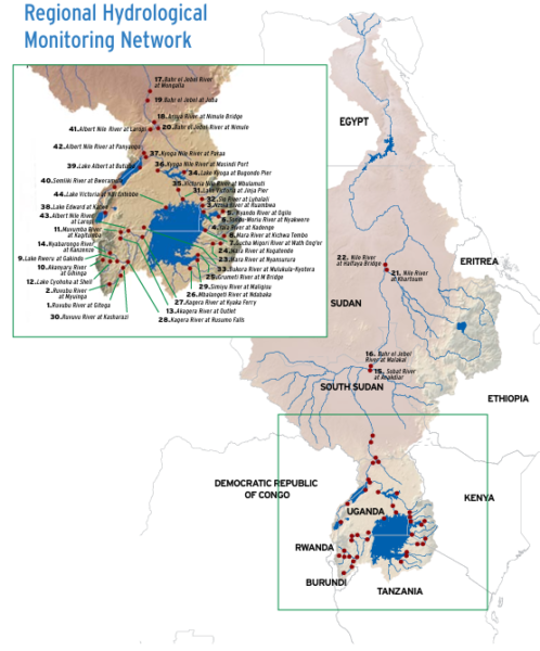
The NBI says its regional hydrological monitoring system is designed to provide real-time information on water quantity and quality and to improve responses to floods and droughts. The organization has also developed drought and flash-flood early-warning systems.
The 2026 country-benefits publication records basin-wide flood and drought early-warning systems covering all ten NBI countries. But the real measure of success cannot be the existence of a website, sensor or database. The test must be behavioral: Did a district evacuate people earlier? Did farmers change planting decisions? Did a dam operator adjust operations? Did a health facility prepare? Did a community protect livestock? Did a road closure happen before the flood rather than after it? The move from prediction to action is therefore one of the most important frontiers in Nile cooperation.
Food & Market Connect us: when the solution meets the fish
If there is one place where the limits of water cooperation become painfully visible, it is Lake Edward. Lake Edward lies between Uganda and the Democratic Republic of Congo within the Nile Basin. Its fish support thousands of people. But the fishery is under severe pressure.
A 2024 investigation published by the Pulitzer Center and produced with InfoNile documented a dramatic decline in catches in parts of the lake. Delphin Mutahinga, a local representative of the North Kivu provincial governor, said production at Vitshumbi had fallen from about 15,000 tonnes to less than 400 tonnes a year. Muhindo Vyalengekanya Joël, a leader of a Kyavinyonge fishermen’s group, pointed to another problem.
“The number of canoes on the lake has tripled,” he said. “A number of 1,187 fishing units are legally authorized, but currently there are more than 4,000 canoes on Lake Edward.”
That is not simply a fishing problem. It is a governance problem. It is an ecosystem problem. It is an enforcement problem. And because the lake is shared, it is also a transboundary problem. Illegal fishing on one side can undermine conservation on the other.
Pollution does not stop at a border. Fish move. People move. Markets move. Conflict moves. The lake therefore makes the case for cooperation from the opposite direction: it shows what happens when governance struggles to keep pace with ecological and economic pressure.
The fishery also exposes a dangerous gap
The NBI’s country-benefits report records investments in Lake Edward and Lake Albert fisheries management, including patrol boats, fish-landing infrastructure, reduced post-harvest losses, water-quality monitoring and strengthened fisheries governance between Uganda and the DRC. Those are real interventions.
But the 2024 reporting from Lake Edward shows that infrastructure alone cannot solve the problem. Illegal fishing, weak enforcement, corruption, armed groups and ecological degradation interact.
Muhindo described “the use of illegal fishing gear and fishing in breeding areas.”
Kambale Steven, an environmental officer in Kyavinyonge, described “enforcement operations in which illegal electric fishing nets were seized. A fisherman interviewed for the investigation alleged that payments were made to intermediaries connected to officials to obtain permission to fish illegally.“
These allegations are serious and should not be generalized beyond the individuals and locations described by the investigation. But they illustrate an important point: A transboundary water solution must include governance. You cannot build a fish-landing site and declare a fishery sustainable. You cannot install a patrol boat and assume enforcement has been solved. You cannot publish a fisheries regulation and assume fishermen will follow it. Solutions must survive contact with local incentives, corruption, insecurity, poverty and environmental change.
The climate is changing the terms of the bargain
The Nile Basin’s development challenge is becoming more difficult because the climate itself is becoming less predictable. The WMO’s 2024 global water report described a hydrological cycle increasingly characterized by extremes. Its State of the Climate in Africa 2024 report similarly warned that droughts and floods are destroying lives and livelihoods across the continent.
For Nile Basin communities, climate change is not a future scenario. It is already altering agricultural calendars, flood risk, water availability and fisheries. That makes the logic of cooperation stronger. One country cannot create a regional flood forecast alone. One country cannot manage a shared aquifer alone. One country cannot protect a shared lake ecosystem alone. And one country cannot build a regional electricity market alone. The Nile is increasingly becoming a test of whether governments can cooperate at the speed of environmental change.
Cooperation is not charity
There is a tendency to describe transboundary water cooperation as diplomatic goodwill. That is too soft. Cooperation is also an economic strategy. The World Bank has argued that regional water cooperation can strengthen resilience by improving the three foundations of water management: information, institutions and infrastructure. The three are inseparable. Information without institutions remains unused. Institutions without infrastructure have limited reach. Infrastructure without information can become dangerous. And infrastructure without accountable institutions can produce unequal benefits.
The strongest Nile projects therefore combine all three. Rusumo combines shared generation and transmission infrastructure with regional governance. Angololo combines water infrastructure with bilateral institutions and environmental safeguards. The groundwater programme combines physical water access with shared data and scientific cooperation.
Early-warning systems combine forecasting technology with institutional coordination and community action. Fisheries management combines infrastructure, enforcement, ecosystem science and cross-border governance. This is the architecture of the Nile’s other story.
But promises still have to survive reality
There is a danger in celebrating the cooperation story too quickly. NBI itself acknowledges that many major investments remain in preparation or financing stages. Angololo is one example. Its expected benefits are substantial, but the benefits are not yet equivalent to completed infrastructure.
Similarly, climate-resilience systems can produce better forecasts without automatically producing better outcomes. Groundwater pilots can shorten water-collection distances while still confronting maintenance, regulation and data problems. Fisheries programmes can provide landing sites while illegal fishing continues.
Hydropower can deliver electricity while affected communities continue to demand safeguards and environmental restoration. That is why the most credible conclusion is not that the Nile has solved cooperation. It has not. The evidence suggests something more interesting: The Basin is learning how cooperation can work and the learning is becoming increasingly tangible.
What the communities are really asking for
Listen closely to the people living around these projects and the demands are remarkably consistent. They want water that arrives when it is needed. Electricity that is reliable. Roads that remain usable during rain. Markets that work. Fish stocks that survive. Warnings that arrive before disasters. Jobs that last beyond construction. Environmental restoration that is more than a promise. And institutions that listen before decisions are made.
That last point may be the most important. A recent public reflection from the Nile Basin Discourse’s Regional Nile Women Network called for moving beyond simply counting women’s representation toward ensuring that women living with water scarcity, floods, degraded wetlands and changing agricultural conditions can bring their knowledge into policy spaces. That is the missing bridge between regional policy and community reality.
People should not be treated only as beneficiaries. They are evidence holders. Farmers know when rainfall patterns change. Fishermen know when catches decline. Women know how much time water collection consumes. Local traders know when roads and markets stop functioning. Communities know where floods first arrive. Their knowledge can complement hydrological models, satellite observations and official statistics.
The next Nile revolution may be a data revolution
The Nile Basin is entering a period in which the most valuable resource may not always be water itself. It may be trustworthy information about water. Where is it? How much is there? How quickly is it changing? Who uses it? Who is exposed to risk? What happens upstream? What happens downstream? What happens underground? And who gets warned?
The NBI’s regional hydrological monitoring systems, groundwater data loggers, water-quality database and early-warning platforms point toward a more connected basin. But data must remain public-interest infrastructure. The people who generate information should eventually see its value returned to them.
A farmer should benefit from the forecast. A fisher should benefit from the lake-monitoring system. A district should benefit from flood-risk mapping. A woman should benefit from water infrastructure that reduces unpaid labour. A policymaker should be able to see evidence across borders rather than relying on fragmented national datasets. That is how data becomes development.
From river politics to river citizenship
The most powerful transformation taking place in the Nile Basin may therefore be cultural. The river is slowly being understood less as a line separating national interests and more as a system connecting them. That does not erase legitimate national interests. Egypt still has legitimate concerns about downstream water security. Sudan has legitimate concerns about dam operations and agricultural water. Ethiopia has legitimate development and energy needs.
Uganda, Kenya, Rwanda, Burundi, Tanzania, South Sudan and the Democratic Republic of Congo have their own needs for food, water, energy, livelihoods and climate resilience. The challenge is not to pretend those interests are identical. They are not. The challenge is to discover where they overlap. Energy can be shared. Forecasts can be shared. Data can be shared. Fisheries can be managed jointly. Aquifers can be monitored together. Infrastructure can be designed across borders. And benefits can be distributed more equitably. That is the practical meaning of a shared basin.
A different measure of success
Perhaps the Nile needs a new development scoreboard. Not only: How many megawatts were generated? But: How many households gained reliable electricity? Not only: How many hectares were designed for irrigation? But: How many farmers actually irrigated their crops? Not only: How many early-warning systems were installed? But: How many people acted on the warning? Not only: How many kilometres of watershed were restored? But: Did water quality improve? Did erosion decline? Did farms become more productive? Not only:
How many women participated in consultations? But: Did their knowledge change the decision? Not only: How many countries signed an agreement? But: Did cooperation change life at the border? Those questions turn a development project into an accountability framework.
The river has not changed its nature. The politics around it can
At Rusumo, a farmer saw a bridge become a market. At Angololo, two countries are attempting to turn a shared river into irrigation, drinking water, hydropower and flood protection. In the Kagera aquifer, scientists are building systems to understand water that cannot be seen from the surface.
Across Ethiopia, Rwanda, South Sudan, Sudan and Uganda, institutions are working to make warnings travel before floods. At Lake Edward, fishermen are showing what happens when resource pressure overwhelms governance. These stories are not evidence that the Nile has entered an age without conflict.
They are evidence of something more credible. The Basin is building mechanisms through which countries can pursue national development while also creating regional benefits. The work is unfinished. Some projects are completed. Some are under construction. Some are still seeking finance. Some are pilots. Some are struggling. Some are producing unintended consequences that must be confronted.
But together they point toward a different future. The Nile does not have to be understood only as a river over which countries disagree. It can also be understood as a river around which countries learn to cooperate. The question now is whether that cooperation can travel the final distance.
From ministers to communities. From agreements to implementation. From data to decisions. From infrastructure to livelihoods. From promises to measurable results. And ultimately, from the river to the people. Because the future of the Nile will not be decided only by what governments build on its waters. It will be decided by what ordinary people can build with the opportunities those waters create.
That is the Nile’s other story. And it may be the story that matters most.
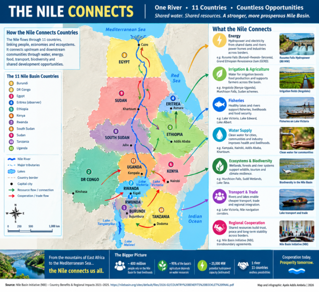
Source: Nile Basin Initiative, NBI Country Benefits & Regional Impacts 2021–2025; NBI project materials; UNDRR regional early-warning reporting.
THE RIVER THAT CONNECTS MORE THAN WATER
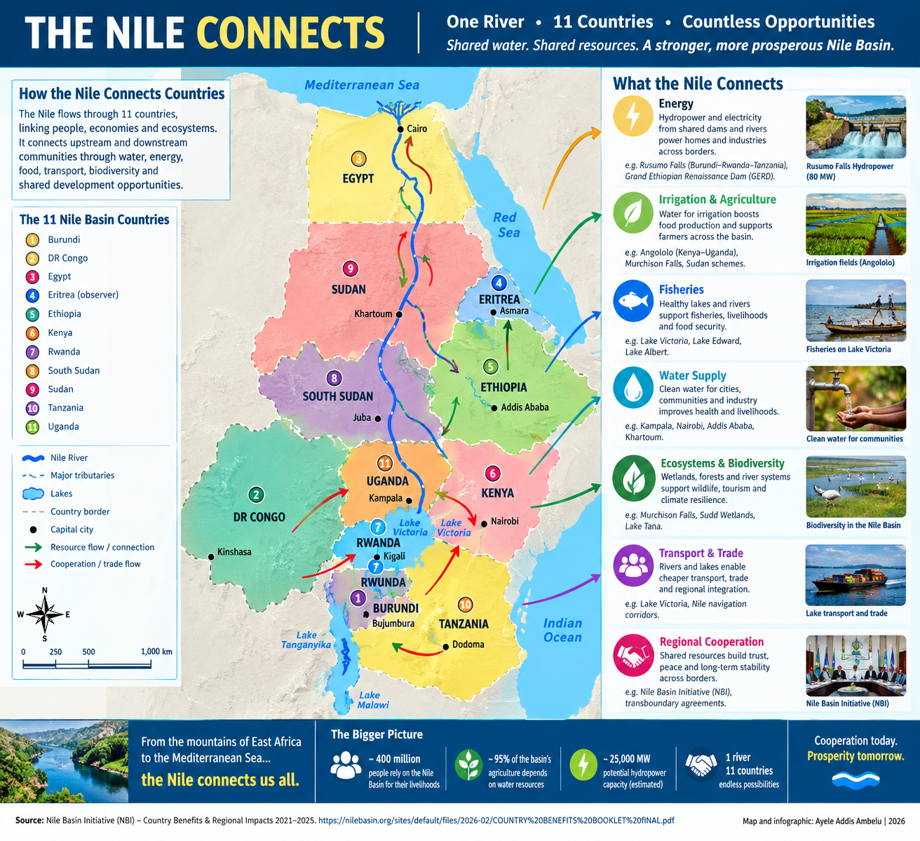
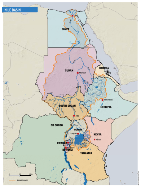
Look at the Nile Basin on a map and the borders can appear to tell one story: eleven countries, different governments, different economies and different national interests. But follow the river lines, tributaries, lakes and shared aquifers, and another story emerges.
The Nile does not recognize the political lines drawn across East and North Africa. Water moves from highlands to wetlands, from rivers into lakes, from upstream catchments toward downstream communities. And increasingly, the infrastructure built around that water is creating connections that are bigger than the river itself.
Water connects to power. Power connects to industry. Irrigation connects farmers to food markets. Lakes connect fishermen to consumers. Climate information connects scientists to communities. And cooperation connects all of them.
The Nile Basin Initiative says the basin crosses Burundi, the Democratic Republic of Congo, Egypt, Eritrea, Ethiopia, Kenya, Rwanda, South Sudan, Sudan, Tanzania and Uganda. Ten countries are NBI member states, while Eritrea participates as an observer. The initiative was established in 1999 around the idea that countries sharing the river could pursue development through cooperation rather than treating the basin only as a source of competing national interests. That idea becomes visible when the map is followed from one border to another.
BURUNDI – RWANDA – TANZANIA: WATER BECOMES ELECTRICITY
At the border area where Burundi, Rwanda and Tanzania meet, the Rusumo Falls Regional Hydroelectric Project provides one of the clearest examples of how a shared water resource can become a shared economic asset.
The 80-megawatt project is jointly owned by the three countries. Its electricity is transmitted through a regional network connecting their national grids. NBI reported that between November 2023 and January 31, 2024, Rusumo delivered 66 million kilowatt-hours of electricity to the three countries: 22 million kWh to Burundi and 21 million kWh each to Rwanda and Tanzania.
The physical connection is equally important. The three national grids were interconnected and synchronized in March 2024 through 372 kilometres of 220-kV transmission lines. This is more than electricity. It means that water flowing through a shared river system can help power homes, businesses and industries in three countries simultaneously.
Eng. Alloyce Oduor, Rusumo project manager, explained that the allocation of 27 MW to each country has different significance depending on the size of each national electricity system. For Burundi, he said, the allocation represents a significant share of peak demand; for Rwanda it is also substantial; while in Tanzania it can help stabilize voltage in the northern and north-western parts of the country.
The project therefore demonstrates an important principle: the benefit of a transboundary river does not have to stop at the border where the water is located. NBI has described Rusumo as an example of transboundary collaboration capable of supporting industrialization, water, health, education and other economic activities.
And the cooperation is continuing beyond construction. In 2026, NBI and the Rusumo Power Company agreed to strengthen hydrological monitoring and information sharing around the plant. The monitoring system covers rivers in Burundi, Rwanda and Tanzania, allowing the countries to use shared information for power-generation planning and catchment management. The river, in other words, is connecting water management to electricity management.
KENYA – UGANDA: ONE RIVER, MANY BENEFITS
Further north, the map leads to the Malaba River, where Kenya and Uganda are developing the Angololo Water Resources Development Project. Here the connection is different. The proposed project is designed to provide potable water to about 270,000 people, irrigate approximately 4,000 hectares, generate 1.3 MW of hydropower, and manage a catchment of about 447 square kilometres.
The project is also expected to support agriculture, livestock, fisheries, employment, water supply, climate adaptation and watershed restoration. This is the logic of a multipurpose river project: instead of asking what one country can extract from a shared river, the question becomes what both countries can gain by managing it together.
Dr Isaac Alukwe, NELSAP-CU Regional Coordinator, put the human dimension bluntly:
“This project is not just about infrastructure; it’s about people.”
That distinction matters.
A dam is concrete. An irrigation canal is concrete. A power station is concrete. But the purpose of all that infrastructure is ultimately measured in human lives, whether farmers can produce more, whether households can access clean water, whether young people can find economic opportunities and whether communities become more resilient to floods and drought.
Dr Florence Adongo, Executive Director of NBI, described the Angololo agreement as a “transition from years of negotiation to implementation”, adding that “shared waters serve as a catalyst for peace and prosperity.”
The map therefore shows a connection that cannot be captured by the word “water” alone: Kenya + Uganda → Malaba River → water + irrigation + hydropower + fisheries + agriculture + jobs + climate resilience.
UGANDA – DEMOCRATIC REPUBLIC OF CONGO: WHEN A LAKE BECOMES A LIVELIHOOD
Move west on the map and Lake Edward tells another story. Here, the shared resource is not primarily a dam. It is a lake and its fisheries. The Nile Basin Initiative’s Lakes Edward and Albert Integrated Fisheries programme focuses on harmonizing policies, strengthening collaborative fisheries organizations, restoring lake shores and spawning sites, and improving joint fisheries and water-resource monitoring.
The expected economic impact is significant. NBI estimates that the programme could contribute to approximately 45,000 direct and indirect jobs, with about half expected to benefit women. The connection is therefore between water quality and household income. A healthy lake means fish. Fish mean food. Fish also mean income for fishermen, processors, traders, transporters and market communities.
But the connection also works in reverse. If pollution, overfishing, degraded shorelines or climate variability damage the lake, the economic consequences cross the border with the water. That is why cooperation becomes more than diplomacy. It becomes a practical requirement for protecting livelihoods.
ETHIOPIA – SUDAN: UNDERGROUND WATER, SHARED KNOWLEDGE
Not all Nile connections can be seen on a map. Some are underground. The Nile Basin Initiative’s groundwater work focuses on shared aquifer systems, including the Gedaref–Adigrat aquifer involving Ethiopia and Sudan, alongside the Kagera and Mount Elgon systems.
In 2026, NBI reported that groundwater pilots in Burundi, Kenya, Rwanda, Tanzania and Uganda were bringing water storage closer to communities. Tanks of up to 60,000 litres have been installed within 500 metres of targeted communities, and NBI reported that a jerrycan could be filled in less than three minutes at the pilot sites.
Dr Maha Abdelraheem Ismail, NBI’s regional groundwater project lead, made a powerful point:
“Groundwater is fundamentally a gender issue.”
Her explanation changes the way the resource should be understood. In many communities, women and girls carry much of the responsibility for collecting water. NBI says women can spend up to a quarter of their day fetching water in parts of Africa.
Reducing the distance between women and water therefore does more than improve water access. It can release time for education, income generation, farming, business and family life.
The connection is: shared aquifer → water access → reduced collection time → women’s economic opportunity → stronger communities. And because aquifers cross political borders underground just as rivers cross borders above ground, scientific cooperation becomes essential.
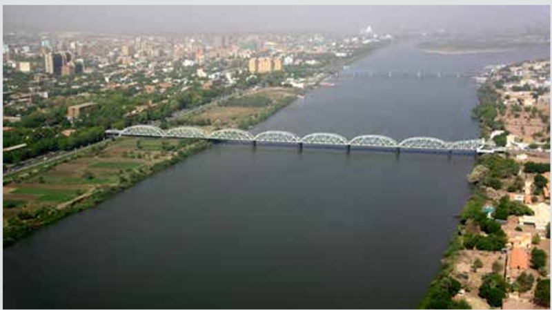
Khartoum
ETHIOPIA – SOUTH SUDAN – SUDAN – UGANDA – RWANDA: DATA BECOMES A SHIELD
There is another connection that is almost invisible: information. Floods do not wait for governments to finish meetings. Droughts do not stop at customs posts. That is why regional climate and hydrological data can become as important as physical infrastructure.
The Nile Cooperation and Climate Resilience programme has supported regional hydrological monitoring, water-quality information, climate-risk management and early-warning systems. In April 2026, UNDRR reported that representatives from Ethiopia, Rwanda, South Sudan, Sudan and Uganda were working with regional and international partners to improve integrated risk assessment and flood early-warning systems.
Pieter Copper, Deputy Head of Mission at the Netherlands Embassy in Rwanda, summarized the challenge:
“Climate data is essential, but data alone is not enough unless it is translated into policies, contingency planning, and action at community level.”
That sentence captures the next stage of Nile cooperation. The value of data is not in the database. Its value is in what happens after the warning. A flood forecast should become an evacuation decision. A drought forecast should become an agricultural decision. A water-quality alert should become a public-health response.
The connection is therefore: country → data → regional system → warning → local action → lives and livelihoods protected.
FROM RIVER TO REGION
Seen this way, the Nile is not one resource. It is a connected system of resources. Burundi, Rwanda and Tanzania demonstrate how shared water can become shared electricity.
Kenya and Uganda demonstrate how a shared river can become water supply, irrigation, hydropower, fisheries and agricultural opportunity. Uganda and the Democratic Republic of Congo demonstrate how shared lakes can connect fisheries, food security, employment and ecosystem protection.
Ethiopia and Sudan demonstrate why underground water resources require scientific cooperation that crosses national borders. And across Ethiopia, Rwanda, South Sudan, Sudan and Uganda, climate information is becoming another form of shared infrastructure, one that can warn communities before floods and droughts become disasters.
The Nile Basin Initiative’s wider portfolio connects these sectors through regional cooperation in energy, water resources, climate resilience, ecosystems and livelihoods. That is why the most important line on a Nile map may not actually be the blue line representing the river.
It may be the invisible lines connecting one country to another: water to electricity; electricity to industry; irrigation to food; lakes to livelihoods; groundwater to women’s time; data to early action;
and cooperation to shared prosperity.
The great question for the Nile is no longer simply who gets the water? It is increasingly: What can countries create together because the water connects them? That may be the Nile’s other story not a river that merely crosses borders, but a river that gives countries reasons to cross them together.